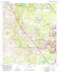
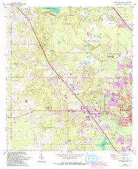
1966 Map of Gainesville West
USGS Topo · Published 1986About this map
The San Felasco Hammock State Preserve dominates the northern landscape of this Alachua County quadrangle, showing a mosaic of wetlands and forests as they appeared in the mid-1960s. This survey records the expanding western residential fringes of Gainesville, where newer developments like Suburban Heights and Chantilly Acres contrast with older landmarks and institutional lands. The presence of the University of Florida Agricultural Experimental Station and the University of Florida Experimental Farm highlights the region's academic and agricultural roots.
Find a feature on this map
53 named features on this map. Tap any name to fly to it.
Don’t see what you’re looking for? This feature index may not catch every label — zoom into the map to look around manually.
Map Details
Editions of this 1966 Gainesville West Map
6 editions found
Other maps of this area

1890 · Arredondo
USGS Topo · 1:62,500

1892 · Arredondo
USGS Topo · 1:62,500

1894 · Arredondo
USGS Topo · 1:62,500

1954 · Gainesville
USGS Topo · 1:250,000

1958 · Gainesville
USGS Topo · 1:250,000

1959 · Gainesville
USGS Topo · 1:250,000

1962 · High Springs
USGS Topo · 1:24,000
1966 · Micanopy
USGS Topo · 1:24,000

1966 · Gainesville West
USGS Topo · 1:24,000

1966 · Arredondo
USGS Topo · 1:24,000