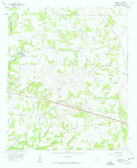
1959 Map of Garner
USGS Topo · Published 1960About this map
The community of Garner serves as a focal point for this landscape in the late 1950s, situated along the Weatherford Mineral Wells and Northwestern railroad. The map reveals a rural network of family-named settlements and cemeteries that speak to the area's pioneer roots, including Author, Lemley, and Preble. Small country churches like Newberry Ch and Beulah Ch anchor the scattered homesteads, while the topography is defined by the winding paths of Grindstone Creek and Lick Branch. In the northwest, the Camp Wolters Military Reservation Bdy marks the edge of the regional military footprint. The layout of transport is clear, with the Texas and Pacific line traversing the southern portion of the quadrangle, passing through the County Memorial Cem area. This map preserves a view of Parker County before modern suburban expansion, highlighting a time when local life was closely tied to these specific rail lines and creek drainages.
Find a feature on this map
36 named features on this map. Tap any name to fly to it.
Don’t see what you’re looking for? This feature index may not catch every label — zoom into the map to look around manually.
Map Details
Editions of this 1959 Garner Map
Other maps of this area

1891 · Weatherford
USGS Topo · 1:125,000

1891 · Palo Pinto
USGS Topo · 1:125,000

1893 · Weatherford
USGS Topo · 1:125,000

1918 · Palo Pinto
USGS Topo · 1:125,000

1927 · Mineral Wells
USGS Topo · 1:62,500

1931 · Dennis
USGS Topo · 1:62,500

1931 · Santo
USGS Topo · 1:62,500

1954 · Dallas
USGS Topo · 1:250,000

1954 · Abilene
USGS Topo · 1:250,000

1958 · Dallas
USGS Topo · 1:250,000