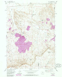
1958 Map of Gas Hills
USGS Topo · Published 1985About this map
Uranium mining operations define the mid-century industrial landscape of the Gas Hills and Dutton Basin regions. This 1958 survey, later updated with aerial data through 1980, centers on the Lucky Mac Uranium Mill and the nearby Lucky Mac Camp, illustrating the specialized infrastructure of Wyoming's Cold War-era energy industry. A long Pipeline and multiple oil wells cut across the high desert terrain, which is bounded to the south by the prominent ridge of the Beaver Divide. The landscape is a network of arid drainage systems like Fraser Draw and West Canyon Creek, supported by man-made water features such as Medicine Springs Reservoir and Iron Springs Reservoir. The map also captures the essential transportation links for this isolated industrial hub, including a Landing Strip and the border between Fremont and Natrona counties.
Find a feature on this map
20 named features on this map. Tap any name to fly to it.
Don’t see what you’re looking for? This feature index may not catch every label — zoom into the map to look around manually.
Map Details
Editions of this 1958 Gas Hills Map
3 editions found
Other maps of this area

1952 · Ervay Basin SW
USGS Topo · 1:24,000

1952 · Love Ranch
USGS Topo · 1:24,000

1952 · Gas Hills
USGS Topo · 1:24,000

1952 · Puddle Springs
USGS Topo · 1:24,000

1952 · Miles Ranch
USGS Topo · 1:24,000

1952 · Coyote Springs
USGS Topo · 1:24,000

1952 · Ervay Basin
USGS Topo · 1:24,000

1952 · Mc Intosh Meadows
USGS Topo · 1:24,000

1955 · Casper
USGS Topo · 1:250,000

1957 · Miles Ranch
USGS Topo · 1:24,000