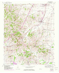
1952 Map of Gates
USGS Topo · Published 1982About this map
The Illinois Central railroad anchors the local geography of Lauderdale County on this survey, cutting a direct path through the communities of Halls and Gates. This corridor served as a vital agricultural artery for Western Tennessee, connecting the scattered hamlets and family farmsteads that define the landscape. To the west, the terrain rises into prominent features like Knob and Dry Hill, while the eastern portion transitions into the drainage basins of Sumrow Creek and Tisdale Creek.
Find a feature on this map
36 named features on this map. Tap any name to fly to it.
Don’t see what you’re looking for? This feature index may not catch every label — zoom into the map to look around manually.
Map Details
Editions of this 1952 Gates Map
3 editions found
Other maps of this area

1939 · Hales Point
USGS Topo · 1:62,500

1939 · Halls
USGS Topo · 1:62,500

1952 · Hales Point
USGS Topo · 1:62,500

1952 · Gates
USGS Topo · 1:24,000

1952 · Bonicord
USGS Topo · 1:24,000

1952 · Chestnut Bluff
USGS Topo · 1:24,000

1952 · Fowlkes
USGS Topo · 1:24,000

1956 · Blytheville
USGS Topo · 1:250,000

1959 · Blytheville
USGS Topo · 1:250,000

1961 · Hales Point
USGS Topo · 1:62,500