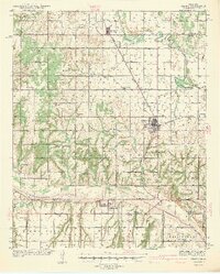
1942 Map of Geary
USGS Topo · Published 1942About this map
The town of Geary serves as a central hub on this 1939 survey, situated at the junction of the Chicago Rock Island and Pacific railroad lines. The landscape is defined by the dual courses of the North Canadian River and the Canadian River, which carve through the Canadian Valley and Mount Valley. This era is marked by a high density of rural schoolhouses, including High Prairie Sch, Richland Sch, and Edenview Sch, which served the farming communities across the Blaine, Canadian, and Caddo county borders. The presence of a CCC Camp near Geary and the Geary Pump Sta reflect the infrastructure and labor programs of the late Depression era. Further south, the settlement of Bridgeport sits near the banks of the Canadian River, connected to the wider region by the legendary Route 66.
Find a feature on this map
42 named features on this map. Tap any name to fly to it.
Don’t see what you’re looking for? This feature index may not catch every label — zoom into the map to look around manually.
Map Details
Editions of this 1942 Geary Map
3 editions found
Other maps of this area

1893 · Fort Reno
USGS Topo · 1:62,500

1893 · Buggy Creek
USGS Topo · 1:62,500

1893 · Loyal
USGS Topo · 1:62,500

1941 · Fort Reno
USGS Topo · 1:62,500

1942 · Fort Reno
USGS Topo · 1:62,500

1942 · Geary
USGS Topo · 1:62,500

1949 · Fort Reno
USGS Topo · 1:62,500

1951 · Binger
USGS Topo · 1:62,500

1955 · Clinton
USGS Topo · 1:250,000

1957 · Clinton
USGS Topo · 1:250,000