
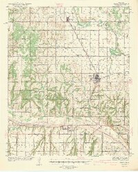
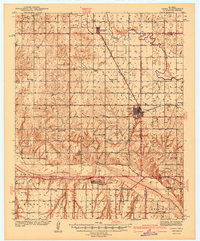
1942 Map of Geary
USGS Topo · Published 1984About this map
Geary stands as a primary railroad hub along the Chicago Rock Island and Pacific line, centered where the river valleys of central Oklahoma converge. This 1939 survey, published in the early 1940s, illustrates a landscape defined by its rural education system, featuring a dense network of country schools such as High Prairie Sch, Richland Sch, and Canadian Valley Sch. These small schoolhouses served a farming community situated between the winding courses of the North Canadian River and the South Canadian River.
Find a feature on this map
40 named features on this map. Tap any name to fly to it.
Don’t see what you’re looking for? This feature index may not catch every label — zoom into the map to look around manually.
Map Details
Editions of this 1942 Geary Map
3 editions found
Other maps of this area

1893 · Fort Reno
USGS Topo · 1:62,500
1893 · Buggy Creek
USGS Topo · 1:62,500
1893 · Loyal
USGS Topo · 1:62,500
1941 · Fort Reno
USGS Topo · 1:62,500

1942 · Fort Reno
USGS Topo · 1:62,500
1942 · Geary
USGS Topo · 1:62,500

1949 · Fort Reno
USGS Topo · 1:62,500
1951 · Binger
USGS Topo · 1:62,500

1955 · Clinton
USGS Topo · 1:250,000

1957 · Clinton
USGS Topo · 1:250,000