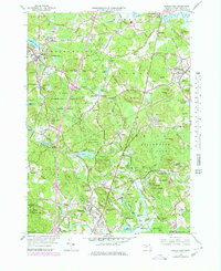
1966 Map of Georgetown
USGS Topo · Published 1979About this map
Georgetown and the surrounding Essex County townships appear here during a period of late-century transition, with new purple revisions from 1977 aerial photography overlaying the 1966 topography. The landscape is defined by its deep educational and institutional roots, featuring the Governor Dummer Academy and Our Lady of LaSalette Seminary, alongside the Adelynrood Retreat in South Byfield. This era shows the older rail network in flux, with the Boston and Maine RR and Conrail corridors cutting through the woodland and marsh.
Find a feature on this map
91 named features on this map. Tap any name to fly to it.
Don’t see what you’re looking for? This feature index may not catch every label — zoom into the map to look around manually.
Map Details
Editions of this 1966 Georgetown Map
2 editions found
Other maps of this area

1886 · Lawrence
USGS Topo · 1:62,500

1888 · Newburyport
USGS Topo · 1:62,500

1888 · Haverhill
USGS Topo · 1:62,500

1888 · Lawrence
USGS Topo · 1:62,500

1888 · Salem
USGS Topo · 1:62,500

1890 · Haverhill
USGS Topo · 1:62,500

1890 · Newburyport
USGS Topo · 1:62,500

1893 · Salem
USGS Topo · 1:62,500

1893 · Lawrence
USGS Topo · 1:62,500

1893 · Haverhill
USGS Topo · 1:62,500