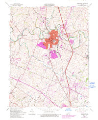
1965 Map of Georgetown
USGS Topo · Published 1993About this map
Georgetown serves as the focal point of this Scott County survey, where the historic campus of Georgetown College and Cardome Academy anchor the central landscape. The 1965 data, later updated with 1988 revisions, captures the city's growth alongside traditional Bluegrass features like Royal Spring and the winding North Elkhorn Creek. This era records a significant transition in land use, documenting the expansion of the Kentucky State Horse Park and the Steeplechase Racetrack near Donerail, as the area evolved from traditional farming into a premier equestrian hub. Smaller settlements and rail stops like Paynes Depot and Great Crossing appear alongside the path of the Southern Railroad, illustrating the transport network that sustained these rural communities. Notable local landmarks, including Garth Sch and Stone Hedge Ch, provide valuable touchstones for genealogists tracing family roots in the horse country of central Kentucky.
Find a feature on this map
57 named features on this map. Tap any name to fly to it.
Don’t see what you’re looking for? This feature index may not catch every label — zoom into the map to look around manually.
Map Details
Editions of this 1965 Georgetown Map
4 editions found
Other maps of this area

1906 · Georgetown
USGS Topo · 1:62,500

1908 · Georgetown
USGS Topo · 1:62,500

1927 · Lexington
USGS Topo · 1:48,000

1929 · Cynthiana
USGS Topo · 1:48,000

1929 · Lexington
USGS Topo · 1:62,500

1934 · Cynthiana
USGS Topo · 1:62,500

1939 · Sadieville
USGS Topo · 1:62,500

1950 · Lexington East
USGS Topo · 1:24,000

1950 · Lexington West
USGS Topo · 1:24,000

1952 · Midway
USGS Topo · 1:24,000