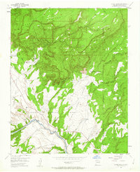
1953 Map of Ghost Ranch
USGS Topo · Published 1963About this map
Ghost Ranch serves as a prominent landmark in this mid-century survey of the Rio Arriba territory. The landscape is defined by the sweeping Llano de la Piedra Lumbre, a broad valley floor punctuated by the Rio Chama winding along its southern edge. This 1951 aerial study captures the area during a period of transition, noting the CCC Camp (Aband) and a small Airstrip near the ranch, which reflect the changing uses of the land from federal work programs to private retreats.
Find a feature on this map
32 named features on this map. Tap any name to fly to it.
Don’t see what you’re looking for? This feature index may not catch every label — zoom into the map to look around manually.
Map Details
Editions of this 1953 Ghost Ranch Map

Other maps of this area

1909 · Gallina
USGS Topo · 1:125,000

1918 · Abiquiu
USGS Topo · 1:125,000

1953 · Canones
USGS Topo · 1:24,000

1953 · Abiquiu
USGS Topo · 1:24,000

1953 · Alire
USGS Topo · 1:24,000

1953 · Echo Ampitheater
USGS Topo · 1:24,000

1953 · Magote Peak
USGS Topo · 1:24,000

1953 · Canjilon
USGS Topo · 1:24,000

1953 · Canjilon SE
USGS Topo · 1:24,000

1953 · Youngsville
USGS Topo · 1:24,000