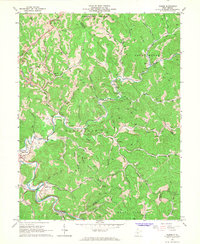
1966 Map of Gilmer
USGS Topo · Published 1968About this map
The Little Kanawha River snakes through the southern reaches of this West Virginia landscape, providing a narrow corridor for the Baltimore and Ohio railroad and the riverfront community of Stouts Mills. This mid-1960s survey illustrates a region defined by its narrow hollows and numerous watercourses, such as Sand Fork and Indian Fork. The topography is dotted with a dense network of oil and gas wells, reflecting the industrial character of the era, while small settlements like Donlan and Ellis serve as local anchors. Family and community heritage is deeply rooted here, evidenced by numerous small burial grounds including Dyer Cem, McHenry Cem, and Edmiston Cem. From the heights of Locust Knob to the industrial presence of a Compressor Sta and several mines, the map documents a transition between agricultural tradition and mineral extraction.
Find a feature on this map
71 named features on this map. Tap any name to fly to it.
Don’t see what you’re looking for? This feature index may not catch every label — zoom into the map to look around manually.
Map Details
Editions of this 1966 Gilmer Map
2 editions found
Other maps of this area

1893 · Sutton
USGS Topo · 1:125,000

1904 · Vadis
USGS Topo · 1:62,500

1906 · Holbrook
USGS Topo · 1:62,500

1906 · Glenville
USGS Topo · 1:62,500

1906 · Burnsville
USGS Topo · 1:62,500

1924 · Holbrook
USGS Topo · 1:62,500

1925 · Glenville
USGS Topo · 1:62,500

1925 · Burnsville
USGS Topo · 1:62,500

1925 · Vadis
USGS Topo · 1:62,500

1926 · Holbrook
USGS Topo · 1:62,500