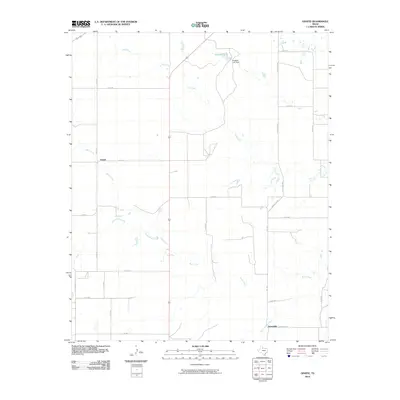
2010 Map of Ginsite
USGS Topo · Published 2010About this map
Ginsite and Sneedville sit within a landscape of rolling Cottle County plains, defined by the winding drainages that feed the North Wichita River system. The settlement at Ginsite serves as a central point for the local road network, where FM 2278 meets a series of county routes that grid the agricultural land. To the north, Salt Creek flows toward Richards Lake, a significant water body held by the Richards Lake Dam. The southern half of the map is dominated by the intricate branching of Buck Creek and South Buck Creek, illustrating the erosional patterns common in this part of North Texas. These waterways, though often seasonal, dictate the placement of ranch roads and crossings across the quadrangle.
Find a feature on this map
29 named features on this map. Tap any name to fly to it.
Don’t see what you’re looking for? This feature index may not catch every label — zoom into the map to look around manually.
Map Details
Editions of this 2010 Ginsite Map
This is the sole edition of this map. No revisions or reprints were ever made.
Other maps of this area

1954 · Lubbock
USGS Topo · 1:250,000

1954 · Plainview
USGS Topo · 1:250,000

1958 · Plainview
USGS Topo · 1:250,000

1966 · Chalk SW
USGS Topo · 1:24,000

1966 · Devils Canyon
USGS Topo · 1:24,000

1967 · Paducah
USGS Topo · 1:24,000

1967 · Moons Camp
USGS Topo · 1:24,000

1968 · Grow
USGS Topo · 1:24,000
1968 · Chalk
USGS Topo · 1:24,000

1968 · Buffalo Creek
USGS Topo · 1:24,000