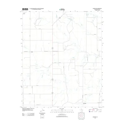
2012 Map of Ginsite
USGS Topo · Published 2012About this map
Ginsite and Sneedville anchor this Cottle County landscape, representing small agrarian nodes in the Rolling Plains region of Texas. The terrain is defined by a dendritic network of seasonal waterways, most notably the N Wichita River along the southern edge and the various branches of Buck Cr. The arrangement of ranch roads and county routes, such as Ranch Road 1038 and Farm-to-Market Road 2278, reflects the sprawling nature of Texas ranching life in the early 21st century. North of the primary settlements, Richards Lake and Salt Cr provide key geographical landmarks in an area otherwise dominated by the open intervals between local pastures and homesteads. This 2012 survey illustrates the persistence of these rural communities and the essential role of water drainage patterns in shaping West Texas settlement.
Find a feature on this map
30 named features on this map. Tap any name to fly to it.
Don’t see what you’re looking for? This feature index may not catch every label — zoom into the map to look around manually.
Map Details
Editions of this 2012 Ginsite Map
This is the sole edition of this map. No revisions or reprints were ever made.
Other maps of this area

1954 · Lubbock
USGS Topo · 1:250,000

1954 · Plainview
USGS Topo · 1:250,000

1958 · Plainview
USGS Topo · 1:250,000

1966 · Chalk SW
USGS Topo · 1:24,000

1966 · Devils Canyon
USGS Topo · 1:24,000

1967 · Paducah
USGS Topo · 1:24,000

1967 · Moons Camp
USGS Topo · 1:24,000

1968 · Grow
USGS Topo · 1:24,000
1968 · Chalk
USGS Topo · 1:24,000

1968 · Buffalo Creek
USGS Topo · 1:24,000