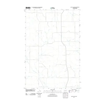
2011 Map of Glen Ullin NE
USGS Topo · Published 2011About this map
Haymarsh Creek winds through the southwestern corner of this Morton County landscape, illustrating the drainage patterns that define the region's agricultural layout. As of this 2011 survey, the area is characterized by a precise grid of rural routes, including County Hwy 88 and County Rd 140, which facilitate movement between sprawling farmsteads. The northeastern portion is marked by the course of Wilson Creek, providing a geographic anchor for the surrounding section lines. This document captures the intersection of natural watercourses and the human-imposed geometry of North Dakota's section-line roads, such as 33 1/2Rd St and 65th Ave, at a time when traditional rural connectivity remained the backbone of the local economy.
Find a feature on this map
21 named features on this map. Tap any name to fly to it.
Don’t see what you’re looking for? This feature index may not catch every label — zoom into the map to look around manually.
Map Details
Editions of this 2011 Glen Ullin NE Map
This is the sole edition of this map. No revisions or reprints were ever made.
Other maps of this area

1954 · Bismarck
USGS Topo · 1:250,000

1954 · McClusky
USGS Topo · 1:250,000

1958 · Bismarck
USGS Topo · 1:250,000

1958 · McClusky
USGS Topo · 1:250,000

1960 · Dengate
USGS Topo · 1:24,000

1960 · Glen Ullin
USGS Topo · 1:24,000

1970 · Hailstone Butte
USGS Topo · 1:24,000

1970 · Glen Ullin NE
USGS Topo · 1:24,000
1970 · Glen Ullin NW
USGS Topo · 1:24,000
1970 · Glen Ullin SW
USGS Topo · 1:24,000