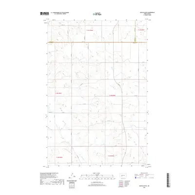
2020 Map of Glen Ullin NE
USGS Topo · Published 2020About this map
Wilson Cr and Haymarsh Cr thread through this section of the Great Plains, defining the drainage patterns in a landscape structured by the Public Land Survey System. The map reveals the intricate network of section lines and rural routes that facilitate movement across the agricultural heartland of North Dakota. Highlighting a significant jurisdictional intersection, the boundary of Mercer Co Oliver Co Morton Co marks a tri-point where three counties meet. Important local thoroughfares like Co Hwy 88 and Co Rd 140 serve as the primary links between disparate homesteads and farmsteads. The topography is meticulously recorded with twenty-foot contour intervals, illustrating the subtle rise and fall of the prairie surrounding these vital watercourses.
Find a feature on this map
23 named features on this map. Tap any name to fly to it.
Don’t see what you’re looking for? This feature index may not catch every label — zoom into the map to look around manually.
Map Details
Editions of this 2020 Glen Ullin NE Map
This is the sole edition of this map. No revisions or reprints were ever made.
Other maps of this area

1954 · Bismarck
USGS Topo · 1:250,000

1954 · McClusky
USGS Topo · 1:250,000

1958 · Bismarck
USGS Topo · 1:250,000

1958 · McClusky
USGS Topo · 1:250,000

1960 · Dengate
USGS Topo · 1:24,000

1960 · Glen Ullin
USGS Topo · 1:24,000

1970 · Hailstone Butte
USGS Topo · 1:24,000

1970 · Glen Ullin NE
USGS Topo · 1:24,000
1970 · Glen Ullin NW
USGS Topo · 1:24,000
1970 · Glen Ullin SW
USGS Topo · 1:24,000