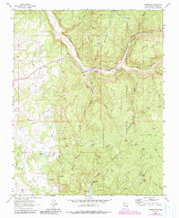
1963 Map of Gobernador
USGS Topo · Published 1981About this map
Carson National Forest terrain dominates this portion of the San Juan Basin, where the deep drainage of La Jara Canyon cuts through high mesas. The 1963 survey captures a landscape defined by its position within a major gas field, evidenced by the numerous Gas Wells and pipelines that crisscross the high ground of Mesteñas Mesa and Laguna Seca Mesa. Settled life is represented by the Gobernador (Site) and the small community at Frances, alongside several remote family-named operations like the Russell Arnold Ranch and Espinosa Ranch. Water is a precious commodity in this arid New Mexico landscape, marked by a series of named sources such as Amarante Spring, Lodge Spring, and the Trujillo Reservoir. Traces of earlier inhabitants are noted by Ruins and a Cem near the Gobernador townsite, indicating a long history of human adaptation to these canyon-and-mesa systems.
Find a feature on this map
44 named features on this map. Tap any name to fly to it.
Don’t see what you’re looking for? This feature index may not catch every label — zoom into the map to look around manually.
Map Details
Editions of this 1963 Gobernador Map
3 editions found
Other maps of this area

1889 · Largo
USGS Topo · 1:250,000

1895 · Largo
USGS Topo · 1:250,000

1954 · Gomez Ranch
USGS Topo · 1:24,000

1954 · Aztec
USGS Topo · 1:250,000

1958 · Aztec
USGS Topo · 1:250,000

1962 · Aztec
USGS Topo · 1:250,000

1963 · Fourmile Canyon
USGS Topo · 1:24,000
1963 · Espinosa Ranch
USGS Topo · 1:24,000

1963 · Gobernador
USGS Topo · 1:24,000
1963 · Pine Lake
USGS Topo · 1:24,000