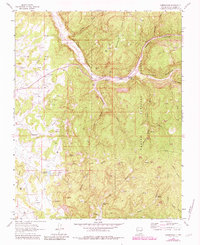
1963 Map of Gobernador
USGS Topo · Published 1983About this map
Carson National Forest spans this high-desert landscape in Rio Arriba County, where the topography is defined by deep incisions like Vaqueros Canyon and La Jara Canyon. By the early 1960s, the region was heavily focused on resource extraction, as evidenced by the dense network of Gas Wells and connecting Pipelines that traverse the mesas. Historical settlement patterns are preserved at the Gobernador (Site), which includes a nearby Cem and sits at the junction of Frances Creek. The map documents a landscape of vital water sources in an arid environment, from the Trujillo Reservoir to numerous named seeps such as Amarante Spring and Skousen Spring. High terrain features like Mestenas Mesa and Laguna Seca Mesa dominate the central and southern portions of the sheet, providing a clear view of the ranching and energy infrastructure that shaped this part of New Mexico.
Find a feature on this map
42 named features on this map. Tap any name to fly to it.
Don’t see what you’re looking for? This feature index may not catch every label — zoom into the map to look around manually.
Map Details
Editions of this 1963 Gobernador Map
3 editions found
Other maps of this area

1889 · Largo
USGS Topo · 1:250,000

1895 · Largo
USGS Topo · 1:250,000

1954 · Gomez Ranch
USGS Topo · 1:24,000

1954 · Aztec
USGS Topo · 1:250,000

1958 · Aztec
USGS Topo · 1:250,000

1962 · Aztec
USGS Topo · 1:250,000

1963 · Fourmile Canyon
USGS Topo · 1:24,000
1963 · Espinosa Ranch
USGS Topo · 1:24,000

1963 · Gobernador
USGS Topo · 1:24,000
1963 · Pine Lake
USGS Topo · 1:24,000