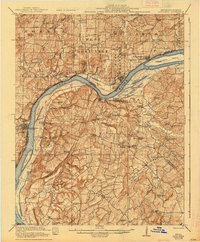
1921 Map of Golconda
USGS Topo · Published 1938About this map
The Ohio River dominates this landscape along the Illinois and Kentucky border, serving as the primary corridor for commerce and transport between Pope and Hardin counties. In this era, the river remains an active thoroughfare where the Berry Ferry provides a vital link near Golconda. The map reveals a densely settled rural landscape defined by an extensive network of country schools and churches that once anchored these small communities. Settlements like Elizabethtown and Rosiclare sit directly on the riverbanks, while the interior is dotted with landmarks like Clemens Store and the St Josephs School. The presence of numerous named schools, including Blooming Rose School and Threlkeld School, alongside topographic features like War Bluff and Hurricane Island, offers a detailed look at the social and physical geography of the Ohio River Valley before mid-century changes.
Find a feature on this map
88 named features on this map. Tap any name to fly to it.
Don’t see what you’re looking for? This feature index may not catch every label — zoom into the map to look around manually.
Map Details
Editions of this 1921 Golconda Map
3 editions found
Other maps of this area

1916 · Shawneetown
USGS Topo · 1:62,500

1916 · Fords Ferry
USGS Topo · 1:62,500

1916 · Golconda
USGS Topo · 1:62,500

1916 · Equality
USGS Topo · 1:62,500

1917 · Brownfield
USGS Topo · 1:62,500

1920 · Goloonda
USGS Topo · 1:48,000

1921 · Fords Ferry
USGS Topo · 1:48,000

1921 · Golconda
USGS Topo · 1:62,500

1925 · Harrisburg
USGS Topo · 1:62,500

1925 · Cave In Rock
USGS Topo · 1:62,500