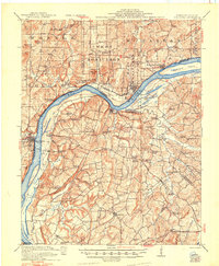
1921 Map of Golconda
USGS Topo · Published 1948About this map
The Ohio River flows through the heart of this region, serving as the defining border between Illinois and Kentucky. In the Illinois territory, the riverfront town of Golconda is a focal point for the Illinois Central railroad and river traffic at Berry Ferry. The landscape is a dense network of rural life, populated by numerous family-named schools and churches that highlight the social fabric of the early 20th century. To the east, the mining town of Rosiclare sits near the Melcher Hills, while across the water in Kentucky, the terrain transitions into a series of hollows and creeks like Coalmine Hollow. The presence of small community hubs like Shetlerville and Elizabethtown alongside landmarks like the Milford Bridge over Deer Creek illustrates a time when commerce was deeply tied to the river's winding course.
Find a feature on this map
97 named features on this map. Tap any name to fly to it.
Don’t see what you’re looking for? This feature index may not catch every label — zoom into the map to look around manually.
Map Details
Editions of this 1921 Golconda Map
3 editions found
Other maps of this area

1916 · Shawneetown
USGS Topo · 1:62,500

1916 · Fords Ferry
USGS Topo · 1:62,500

1916 · Golconda
USGS Topo · 1:62,500

1916 · Equality
USGS Topo · 1:62,500

1917 · Brownfield
USGS Topo · 1:62,500

1920 · Goloonda
USGS Topo · 1:48,000

1921 · Fords Ferry
USGS Topo · 1:48,000

1921 · Golconda
USGS Topo · 1:62,500

1925 · Harrisburg
USGS Topo · 1:62,500

1925 · Cave In Rock
USGS Topo · 1:62,500