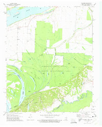
1972 Map of Golddust
USGS Topo · Published 1975About this map
The Mississippi River and the Hatchie River converge in this riverine landscape, where the dynamic shifts of the water have created complex landforms like The Arkansas-Tennessee Chute and Flour Island No 33. In the early 1970s, the area was dominated by protected lands including the Anderson-Tully State Wildlife Management Area and Fort Pillow State Park. The latter preserves significant historical military features, specifically breastworks along the Chickasaw Bluff No 1. Local community life is rooted in settlements like Golddust and the rural surroundings of Bethlehem Ch and Oak Grove Ch. The terrain is a maze of wetlands and secondary waterways such as Cold Slough, Jones Bayou, and Crutcher Lake, illustrating the alluvial character of the border between Tennessee and Arkansas.
Find a feature on this map
48 named features on this map. Tap any name to fly to it.
Don’t see what you’re looking for? This feature index may not catch every label — zoom into the map to look around manually.
Map Details
Editions of this 1972 Golddust Map
3 editions found
Other maps of this area

1939 · Hales Point
USGS Topo · 1:62,500

1939 · Blytheville
USGS Topo · 1:62,500

1952 · Hales Point
USGS Topo · 1:62,500

1955 · Blytheville
USGS Topo · 1:62,500

1956 · Blytheville
USGS Topo · 1:250,000

1959 · Blytheville
USGS Topo · 1:250,000

1961 · Hales Point
USGS Topo · 1:62,500

1961 · Rialto
USGS Topo · 1:62,500

1962 · Rialto
USGS Topo · 1:62,500

1962 · Hales Point
USGS Topo · 1:62,500