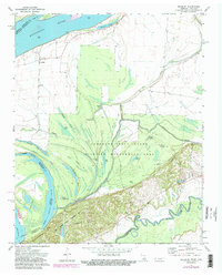
1972 Map of Golddust
USGS Topo · Published 1983About this map
The Mississippi River and its ever-shifting floodplain dominate this riverfront landscape in western Tennessee. The small settlement at Golddust sits on the edge of the river, while the surrounding lowlands are defined by a complex network of backwaters and sloughs, including The Chute, Whale Pond, and Cotton Slough. The intricate relationship between land and water is evident in features like Flour Island No 33 and the Heathright Pocket, which indicate the dynamic nature of the river's path.
Find a feature on this map
48 named features on this map. Tap any name to fly to it.
Don’t see what you’re looking for? This feature index may not catch every label — zoom into the map to look around manually.
Map Details
Editions of this 1972 Golddust Map
3 editions found
Other maps of this area

1939 · Hales Point
USGS Topo · 1:62,500

1939 · Blytheville
USGS Topo · 1:62,500

1952 · Hales Point
USGS Topo · 1:62,500

1955 · Blytheville
USGS Topo · 1:62,500

1956 · Blytheville
USGS Topo · 1:250,000

1959 · Blytheville
USGS Topo · 1:250,000

1961 · Hales Point
USGS Topo · 1:62,500

1961 · Rialto
USGS Topo · 1:62,500

1962 · Rialto
USGS Topo · 1:62,500

1962 · Hales Point
USGS Topo · 1:62,500