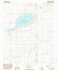
1985 Map of Golden Ranch
USGS Topo · Published 1985About this map
Salt Lake dominates this high plains landscape within the Portales Valley, a region defined by its expansive topography and the significant presence of the Grulla National Wildlife Refuge. This conservation area spans across the state line, where the boundary between New Mexico and Texas meets the local division of Roosevelt and Bailey counties. The map provides a detailed view of the pastoral and industrial character of the mid-1980s, marked by the isolated Golden Ranch and a dense network of water extraction points labeled simply as wells. These features illustrate the vital relationship between the saline basin and the agricultural infrastructure required to sustain life and ranching in this arid borderland environment.
Find a feature on this map
7 named features on this map. Tap any name to fly to it.
Don’t see what you’re looking for? This feature index may not catch every label — zoom into the map to look around manually.
Map Details
Editions of this 1985 Golden Ranch Map
This is the sole edition of this map. No revisions or reprints were ever made.
Other maps of this area

1954 · Clovis
USGS Topo · 1:250,000

1954 · Brownfield
USGS Topo · 1:250,000

1957 · Arch
USGS Topo · 1:62,500

1958 · Brownfield
USGS Topo · 1:250,000

1958 · Clovis
USGS Topo · 1:250,000

1962 · Brownfield
USGS Topo · 1:250,000

1962 · Stegall
USGS Topo · 1:24,000

1962 · Birdwell Ranch
USGS Topo · 1:24,000

1968 · Three Way School
USGS Topo · 1:24,000

1970 · Causey East
USGS Topo · 1:24,000