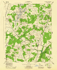
1944 Map of Goldsboro
USGS Topo · Published 1944About this map
The Choptank River headwaters and a complex network of agricultural drainage define this mid-century landscape on the Maryland-Delaware border. At the heart of the region, the Pennsylvania railroad corridor connects the settlements of Goldsboro, Henderson, and Marydel, while the Oxford Branch tracks branch southward. The terrain is marked by engineered waterways like Long Marsh Ditch and Edenburg Ditch, which were critical for the productivity of the surrounding farms and orchards. Small crossroads communities including Hollingsworth Crossroads and Melville Crossroads anchor the rural road system, punctuated by local landmarks such as Bethel Church and the Lockerman Ch. This survey illustrates a period of established rail-and-road transport before modern highway expansions altered the rural character of Caroline and Queen Anne's counties.
Find a feature on this map
31 named features on this map. Tap any name to fly to it.
Don’t see what you’re looking for? This feature index may not catch every label — zoom into the map to look around manually.
Map Details
Editions of this 1944 Goldsboro Map
4 editions found
Other maps of this area

1899 · Dover
USGS Topo · 1:125,000

1905 · Denton
USGS Topo · 1:62,500

1905 · Barclay
USGS Topo · 1:62,500

1906 · Dover
USGS Topo · 1:125,000

1918 · Harrington
USGS Topo · 1:62,500

1920 · Dover
USGS Topo · 1:125,000

1926 · Wyoming
USGS Topo · 1:48,000

1930 · Wyoming
USGS Topo · 1:62,500

1931 · Wyoming
USGS Topo · 1:62,500

1944 · Denton
USGS Topo · 1:31,680