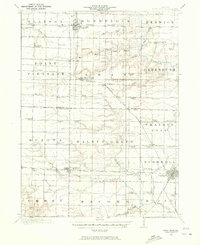
1916 Map of Good Hope
USGS Topo · Published 1972About this map
Good Hope and Bushnell anchor this 1916 agricultural landscape in McDonough County, where the transition from prairie to creek-carved timber is marked by a dense network of country schools and growing rail towns. The topography is defined by the East Fork Crooked Creek and its many tributaries like Short Fork and Drowning Fork, which dictated the early layout of homesteads and roads. For genealogists, the map is remarkably specific, identifying individual landmarks like the curiously named Mud College, the Sugarloaf School, and Salem School.
Find a feature on this map
88 named features on this map. Tap any name to fly to it.
Don’t see what you’re looking for? This feature index may not catch every label — zoom into the map to look around manually.
Map Details
Editions of this 1916 Good Hope Map
2 editions found
Other maps of this area

1912 · Macomb
USGS Topo · 1:62,500

1913 · Colchester
USGS Topo · 1:62,500

1914 · Macomb
USGS Topo · 1:62,500

1915 · Avon
USGS Topo · 1:62,500

1916 · Good Hope
USGS Topo · 1:62,500

1918 · Vermont
USGS Topo · 1:62,500

1918 · La Harpe
USGS Topo · 1:62,500

1918 · Good Hope
USGS Topo · 1:62,500

1921 · Vermont
USGS Topo · 1:62,500

1921 · Monmouth
USGS Topo · 1:62,500