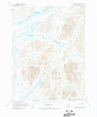
1954 Map of Goodnews A-6
USGS Topo · Published 1984About this map
The Goodnews River watershed dominates this mid-century topographic survey, showing a landscape defined by its intricate drainage systems in the Bethel region. The confluence of the Middle Fork and South Fork reveals the complex hydrologic pattern of this Alaskan wilderness during the 1950s. Farther south, the Osviak River and Tiyagak Creek carve through terrain that remained largely unsurveyed in terms of traditional land lines, as noted by the Bureau of Land Management. This map represents a period of transitional cartography where photogrammetric methods from 1957 aerial photography were integrated with 1954 field annotations, providing a technical look at a roadless coastal interior before modern development or intensive resource mapping altered the primitive character of the river valleys.
Find a feature on this map
5 named features on this map. Tap any name to fly to it.
Don’t see what you’re looking for? This feature index may not catch every label — zoom into the map to look around manually.
Map Details
Editions of this 1954 Goodnews A-6 Map
3 editions found
Other maps of this area

1948 · Hagemeister Island D-3
USGS Topo · 1:63,360

1951 · Goodnews
USGS Topo · 1:250,000

1951 · Hagemeister Island
USGS Topo · 1:250,000

1954 · Goodnews B-7
USGS Topo · 1:63,360

1954 · Goodnews A-7
USGS Topo · 1:63,360

1954 · Hagemeister Island D-4
USGS Topo · 1:63,360

1954 · Goodnews A-6
USGS Topo · 1:63,360

1954 · Goodnews B-6
USGS Topo · 1:63,360

1957 · Hagemeister Island
USGS Topo · 1:250,000

1979 · Goodnews Bay A-5
USGS Topo · 1:63,360