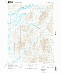
1954 Map of Goodnews A-6
USGS Topo · Published 1984About this map
The Goodnews River defines the hydrologic character of this Alaskan landscape, where the Middle Fork and South Fork create a complex network of waterways across the tundra. Based on aerial photography from 1957 and field annotations from 1954, the map reflects a mid-century era of remote surveying managed by the Bureau of Land Management, which predetermined unsurveyed and unmarked land lines for the region. The terrain is characterized by dramatic elevation changes, notably at Nikolai Hill and along the course of the Osviak River in the south. Unlike more developed regions, this map reveals a wilderness without roads or trails, where the Tinyagak Creek and other smaller tributaries remain the primary geographical landmarks for navigation and land management.
Find a feature on this map
9 named features on this map. Tap any name to fly to it.
Don’t see what you’re looking for? This feature index may not catch every label — zoom into the map to look around manually.
Map Details
Editions of this 1954 Goodnews A-6 Map
3 editions found
Other maps of this area

1948 · Hagemeister Island D-3
USGS Topo · 1:63,360

1951 · Goodnews
USGS Topo · 1:250,000

1951 · Hagemeister Island
USGS Topo · 1:250,000

1954 · Goodnews B-7
USGS Topo · 1:63,360

1954 · Goodnews A-7
USGS Topo · 1:63,360

1954 · Hagemeister Island D-4
USGS Topo · 1:63,360

1954 · Goodnews A-6
USGS Topo · 1:63,360

1954 · Goodnews B-6
USGS Topo · 1:63,360

1957 · Hagemeister Island
USGS Topo · 1:250,000

1979 · Goodnews Bay A-5
USGS Topo · 1:63,360