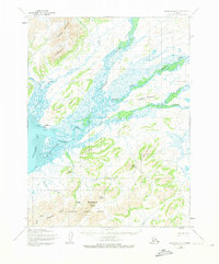
1954 Map of Goodnews A-7
USGS Topo · Published 1973About this map
Goodnews sits at the confluence of several river systems and the head of Goodnews Bay in this mid-century Alaskan survey. The settlement is supported by a local Landing Field and an extensive network of travel routes, including a Tractor Trail and an approximate Winter Trail. The landscape is dominated by the braided drainage patterns of the Goodnews River, which branches into the Middle Fork Goodnews River and South Fork Goodnews River. To the south, the Cape Newenham National Wildlife Refuge encompasses prominent coastal elevations such as Pyramid Mountain and Crater Hill. This coastal-inland transition area shows the essential infrastructure for remote living, from isolated Cabins to traditional Native Trails that navigate between Iktliyagak Mountain and the Eastern Lakes.
Find a feature on this map
35 named features on this map. Tap any name to fly to it.
Don’t see what you’re looking for? This feature index may not catch every label — zoom into the map to look around manually.
Map Details
Editions of this 1954 Goodnews A-7 Map
3 editions found
Other maps of this area

1950 · Hagemeister Island D-5
USGS Topo · 1:63,360

1951 · Goodnews
USGS Topo · 1:250,000

1951 · Hagemeister Island
USGS Topo · 1:250,000

1954 · Goodnews A-8
USGS Topo · 1:63,360

1954 · Goodnews B-7
USGS Topo · 1:63,360

1954 · Goodnews A-7
USGS Topo · 1:63,360

1954 · Goodnews B-8
USGS Topo · 1:63,360

1954 · Hagemeister Island D-5
USGS Topo · 1:63,360

1954 · Hagemeister Island D-4
USGS Topo · 1:63,360

1954 · Goodnews A-6
USGS Topo · 1:63,360