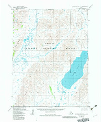
1979 Map of Goodnews Bay A-2
USGS Topo · Published 1983About this map
The Togiak National Wildlife Refuge encompasses nearly the entire landscape in this 1970s-era study, documenting a wilderness of intricate waterways and prominent landforms. The Kulukak River and Kanik River serve as primary drainage systems for the region, while the interior is punctuated by the significant height of Buchia Ridge. Water dominates the eastern half of the map, centered on the expansive Ualik Lake Elevation 54, which is fed and drained by various tributaries including Tithe Creek and Francis Creek. In the far northeast, the Ongoke River winds through the terrain, illustrating the complex hydrology of the Bristol Bay region. This map reflects the period just after the passage of the Alaska National Interest Lands Conservation Act, which formally established many of the conservation boundaries shown here, and it remains a vital reference for understanding the undisturbed topography and water networks before modern environmental shifts.
Find a feature on this map
9 named features on this map. Tap any name to fly to it.
Don’t see what you’re looking for? This feature index may not catch every label — zoom into the map to look around manually.
Map Details
Editions of this 1979 Goodnews Bay A-2 Map
2 editions found
Other maps of this area

1945 · Nushagak Bay
USGS Topo · 1:250,000

1949 · Nushagak Bay
USGS Topo · 1:250,000

1950 · Nushagak Bay D-5
USGS Topo · 1:63,360

1950 · Nushagak Bay D-6
USGS Topo · 1:63,360

1951 · Goodnews
USGS Topo · 1:250,000

1951 · Nushagak Bay
USGS Topo · 1:250,000

1954 · Goodnews B-3
USGS Topo · 1:63,360

1954 · Goodnews A-3
USGS Topo · 1:63,360

1964 · Nushagak Bay
USGS Topo · 1:250,000
1979 · Goodnews Bay A-1
USGS Topo · 1:63,360