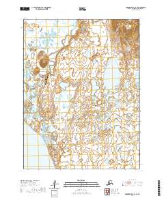
2020 Map of Goodnews Bay A-4 SE
USGS Topo · Published 2020About this map
Twin Hills sits at the base of its namesake terrain, serving as a primary settlement in this coastal area of the Dillingham Census Area. The community is connected to the wider region via the Twin Hills Airport and the local Airport Road, which cuts across the marshy lowlands. The landscape is defined by vast tracts of wetlands and tundra, with the winding Negukthlik River snaking through the eastern portion of the quadrangle. Most of the terrain is a mosaic of small lakes and seasonal ponds, typical of the Bristol Bay region. This 2020 edition detail clarifies the township and range divisions, such as t13s r66w, which govern the land management of this remote subarctic environment.
Find a feature on this map
10 named features on this map. Tap any name to fly to it.
Don’t see what you’re looking for? This feature index may not catch every label — zoom into the map to look around manually.
Map Details
Editions of this 2020 Goodnews Bay A-4 SE Map
This is the sole edition of this map. No revisions or reprints were ever made.
Other maps of this area

1950 · Hagemeister Island D-1
USGS Topo · 1:63,360

1951 · Goodnews
USGS Topo · 1:250,000

1951 · Hagemeister Island
USGS Topo · 1:250,000

1952 · Hagemeister Island D-1
USGS Topo · 1:63,360

1954 · Goodnews A-4
USGS Topo · 1:63,360

1954 · Goodnews A-3
USGS Topo · 1:63,360

1957 · Hagemeister Island
USGS Topo · 1:250,000

1979 · Goodnews Bay
USGS Topo · 1:250,000
2018 · Hagemeister Island D-1 NW
USGS Topo · 1:25,000
2019 · Goodnews Bay A-3 SW
USGS Topo · 1:25,000