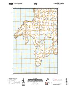
2018 Map of Hagemeister Island D-1 NW
USGS Topo · Published 2018About this map
Togiak serves as the primary coastal settlement on this portion of the Bristol Bay region, situated along the complex shoreline where the mainland meets the Pacific Ocean. This 2018 survey reveals a landscape defined by extensive wetlands and tidal flats, typical of the low-lying coastal plains in Southwest Alaska. The geography is punctuated by significant maritime landmarks such as Anchor Point and Rocky Point, which frame the approaches to Togiak Bay. To the southeast, the secluded waters of Ungadikthluk Bay highlight the intricate coastal indentations that have historically supported subsistence fishing and local navigation. The map's detail illustrates the transition from open sea to protected bay environments, providing a clear record of the shoreline and hydrological patterns around this remote Dillingham Census Area outpost.
Find a feature on this map
10 named features on this map. Tap any name to fly to it.
Don’t see what you’re looking for? This feature index may not catch every label — zoom into the map to look around manually.
Map Details
Editions of this 2018 Hagemeister Island D-1 NW Map
This is the sole edition of this map. No revisions or reprints were ever made.
Other maps of this area

1947 · Hagemeister Island D-2
USGS Topo · 1:63,360

1950 · Hagemeister Island D-1
USGS Topo · 1:63,360

1951 · Goodnews
USGS Topo · 1:250,000

1951 · Hagemeister Island
USGS Topo · 1:250,000

1952 · Hagemeister Island D-1
USGS Topo · 1:63,360

1953 · Hagemeister Island D-2
USGS Topo · 1:63,360

1954 · Goodnews A-4
USGS Topo · 1:63,360

1957 · Hagemeister Island
USGS Topo · 1:250,000

1979 · Goodnews Bay
USGS Topo · 1:250,000
2020 · Hagemeister Island D-2 SE
USGS Topo · 1:25,000