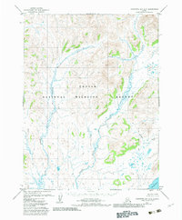
1979 Map of Goodnews Bay A-5
USGS Topo · Published 1983About this map
The Togiak National Wildlife Refuge dominates this coastal Alaska landscape, preserved under the 1980 Alaska National Interest Lands Conservation Act. The map documents a complex drainage system where the Matogak River and Quigmy River flow toward the southern coastline, winding through a terrain defined by wet meadows and numerous small ponds. In the southeast, the Togiak Corporate Boundary meets the waters of Togiak Bay near the mouth of the Kukaktlik River. This survey captures the region just as federal protections were being formalized, showing an area devoid of roads or permanent trails, where the hydrology of Sulutak Creek and neighboring waterways dictated the movement of the local population and wildlife alike.
Find a feature on this map
7 named features on this map. Tap any name to fly to it.
Don’t see what you’re looking for? This feature index may not catch every label — zoom into the map to look around manually.
Map Details
Editions of this 1979 Goodnews Bay A-5 Map
2 editions found
Other maps of this area

1947 · Hagemeister Island D-2
USGS Topo · 1:63,360

1948 · Hagemeister Island D-3
USGS Topo · 1:63,360

1951 · Goodnews
USGS Topo · 1:250,000

1951 · Hagemeister Island
USGS Topo · 1:250,000

1953 · Hagemeister Island D-2
USGS Topo · 1:63,360

1954 · Goodnews A-4
USGS Topo · 1:63,360

1954 · Goodnews A-6
USGS Topo · 1:63,360

1954 · Goodnews B-6
USGS Topo · 1:63,360

1957 · Hagemeister Island
USGS Topo · 1:250,000

1979 · Goodnews Bay A-5
USGS Topo · 1:63,360