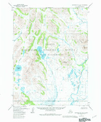
1979 Map of Goodnews Bay B-4
USGS Topo · Published 1983About this map
The Togiak National Wildlife Refuge dominates this sub-arctic landscape, defined by a complex network of glacial lakes and braided river systems. Two historical settlement locations, Tuniakpak (Site) and Kassianmute (Site), are situated along the lower reaches of the Togiak River, offering a glimpse into the seasonal subsistence patterns of the region's inhabitants. The terrain transitions from the elevations of Lone Mountain and unnamed peaks in the Mountains to the low-lying wetlands surrounding Kukaktlim Lake and Gechlak Lake.
Find a feature on this map
16 named features on this map. Tap any name to fly to it.
Don’t see what you’re looking for? This feature index may not catch every label — zoom into the map to look around manually.
Map Details
Editions of this 1979 Goodnews Bay B-4 Map
2 editions found
Other maps of this area

1951 · Goodnews
USGS Topo · 1:250,000

1954 · Goodnews B-3
USGS Topo · 1:63,360

1954 · Goodnews C-4
USGS Topo · 1:63,360

1954 · Goodnews A-4
USGS Topo · 1:63,360

1954 · Goodnews A-3
USGS Topo · 1:63,360

1979 · Goodnews Bay C-5
USGS Topo · 1:63,360

1979 · Goodnews Bay A-5
USGS Topo · 1:63,360

1979 · Goodnews Bay B-5
USGS Topo · 1:63,360

1979 · Goodnews Bay C-3
USGS Topo · 1:63,360

1979 · Goodnews Bay
USGS Topo · 1:250,000