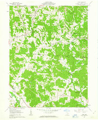
1961 Map of Gore
USGS Topo · Published 1963About this map
The hills and hollows of Perry and Hocking counties show a landscape defined by industry and early land divisions in the early 1960s. This survey area is bisected by the Congress Lands Ohio Company Purchase boundary, a legacy of the early Northwest Territory land distribution. Coal and clay extraction are prominent throughout the terrain, evidenced by numerous Strip Mines and the iron-working history marked by Bessie Furnace near Oreville.
Find a feature on this map
47 named features on this map. Tap any name to fly to it.
Don’t see what you’re looking for? This feature index may not catch every label — zoom into the map to look around manually.
Map Details
Editions of this 1961 Gore Map
Other maps of this area

1903 · Athens
USGS Topo · 1:62,500

1904 · Zaleski
USGS Topo · 1:62,500

1905 · Athens
USGS Topo · 1:62,500

1907 · Zaleski
USGS Topo · 1:62,500

1907 · Logan
USGS Topo · 1:62,500

1909 · Logan
USGS Topo · 1:62,500

1911 · New Lexington
USGS Topo · 1:62,500

1947 · Columbus
USGS Topo · 1:250,000

1961 · Columbus
USGS Topo · 1:250,000

1961 · Nelsonville
USGS Topo · 1:24,000