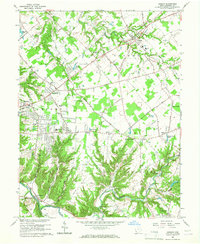
1965 Map of Goshen
USGS Topo · Published 1967About this map
O'Bannon Creek and the East Fork Little Miami River define the undulating landscape of this Clermont County region during the mid-1960s. The settlement pattern shows a shift from traditional crossroads like Williams Corners and Belfast toward suburban development near Mt Repose and Mulberry. The northern half of the sheet is dominated by the community of Goshen, where the High Sch and several churches serve the local population. To the south, the deep valleys and hills surrounding Stonelick Creek and Brushy Fork remain largely rural, contrasted by the industrial presence of the Norfolk and Western Railway passing through Perintown. Notable landmarks of the era include the Drive-in Theater along the Woodville Pike and the Fairacres Golf Club, illustrating the mid-century recreational growth between the larger population centers of Cincinnati and Milford.
Find a feature on this map
66 named features on this map. Tap any name to fly to it.
Don’t see what you’re looking for? This feature index may not catch every label — zoom into the map to look around manually.
Map Details
Editions of this 1965 Goshen Map
Other maps of this area

1898 · East Cincinnati
USGS Topo · 1:62,500

1904 · Mason
USGS Topo · 1:62,500

1906 · Mason
USGS Topo · 1:62,500

1914 · East Cincinnati
USGS Topo · 1:62,500

1914 · Batavia
USGS Topo · 1:48,000

1914 · Morrow
USGS Topo · 1:62,500

1916 · Batavia
USGS Topo · 1:62,500

1916 · Morrow
USGS Topo · 1:62,500

1953 · Withamsville
USGS Topo · 1:24,000

1953 · Goshen
USGS Topo · 1:24,000
Featured Places
- Stonelick Township, OH
- Mulberry, OH
- Owensville, Stonelick Township
- Miami Township, OH
- Union Township, OH