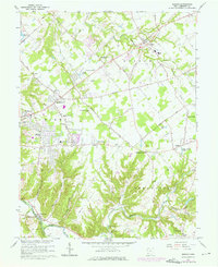
1965 Map of Goshen
USGS Topo · Published 1976About this map
Little Miami River defines the southwestern corner of this Clermont County landscape, where the Norfolk and Western railroad skirts the settlement of Perintown. The terrain transitions from the river valley into a network of creeks and runs, including Stonelick Creek and O'Bannon Creek, which shaped the early development of Goshen and surrounding hamlets. This 1965 survey, updated with 1974 revisions, captures a period of mid-century growth as residential subdivisions began to spread near Mt Repose and Mulberry. Cultural landmarks such as the Drive-in Theater near Springvale and the Covered Bridge on Stonelick Creek sit alongside much older sites. Genealogists will find numerous family-centric locations, including Mt Zion Cem, Olive Cem, and St Louis Cem, as well as local parish centers like St Philomena Ch and Trinity Ch.
Find a feature on this map
67 named features on this map. Tap any name to fly to it.
Don’t see what you’re looking for? This feature index may not catch every label — zoom into the map to look around manually.
Map Details
Editions of this 1965 Goshen Map
Other maps of this area

1898 · East Cincinnati
USGS Topo · 1:62,500

1904 · Mason
USGS Topo · 1:62,500

1906 · Mason
USGS Topo · 1:62,500

1914 · East Cincinnati
USGS Topo · 1:62,500

1914 · Batavia
USGS Topo · 1:48,000

1914 · Morrow
USGS Topo · 1:62,500

1916 · Batavia
USGS Topo · 1:62,500

1916 · Morrow
USGS Topo · 1:62,500

1953 · Withamsville
USGS Topo · 1:24,000

1953 · Goshen
USGS Topo · 1:24,000
Featured Places
- Stonelick Township, OH
- Mulberry, OH
- Owensville, Stonelick Township
- Miami Township, OH
- Union Township, OH