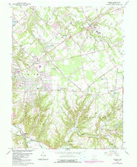
1965 Map of Goshen
USGS Topo · Published 1987About this map
The Little Miami River valley and its surrounding townships define this 1965 survey, documenting a period of suburban expansion within the Virginia Military District. Several established settlements including Goshen, Mt Repose, and Mulberry are mapped alongside newer residential developments like Springvale and several trailer parks. This era shows a landscape in transition, where legacy features like the Covered Bridge near Stonelick Creek and the St Philomena Ch stand near mid-century additions such as the Drive-in Theater and the Fairacres Golf Club.
Find a feature on this map
66 named features on this map. Tap any name to fly to it.
Don’t see what you’re looking for? This feature index may not catch every label — zoom into the map to look around manually.
Map Details
Editions of this 1965 Goshen Map
Other maps of this area

1898 · East Cincinnati
USGS Topo · 1:62,500

1904 · Mason
USGS Topo · 1:62,500

1906 · Mason
USGS Topo · 1:62,500

1914 · East Cincinnati
USGS Topo · 1:62,500

1914 · Batavia
USGS Topo · 1:48,000

1914 · Morrow
USGS Topo · 1:62,500

1916 · Batavia
USGS Topo · 1:62,500

1916 · Morrow
USGS Topo · 1:62,500

1953 · Withamsville
USGS Topo · 1:24,000

1953 · Goshen
USGS Topo · 1:24,000
Featured Places
- Stonelick Township, OH
- Mulberry, OH
- Owensville, Stonelick Township
- Miami Township, OH
- Union Township, OH