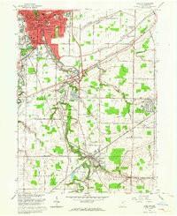
1963 Map of Grafton
USGS Topo · Published 1964About this map
Industrial expansion and postwar suburban development define the landscape around Elyria and Grafton during the early 1960s. The southern reach of the city shows a dense network of streets and institutions like Gates Hospital and Eastern Heights Sch, while the surrounding townships maintain a patchwork of agriculture and emerging residential clusters. Significant infrastructure projects such as the Ohio Turnpike and the New York Central System intersect the region, facilitating the movement of goods and people between the growing centers of Carlisle and Eaton.
Find a feature on this map
62 named features on this map. Tap any name to fly to it.
Don’t see what you’re looking for? This feature index may not catch every label — zoom into the map to look around manually.
Map Details
Editions of this 1963 Grafton Map
4 editions found
Other maps of this area

1901 · Oberlin
USGS Topo · 1:62,500

1902 · Berea
USGS Topo · 1:62,500

1903 · Oberlin
USGS Topo · 1:62,500

1904 · Berea
USGS Topo · 1:62,500

1904 · Medina
USGS Topo · 1:62,500

1904 · Wellington
USGS Topo · 1:62,500

1906 · Medina
USGS Topo · 1:62,500

1906 · Wellington
USGS Topo · 1:62,500

1950 · Cleveland
USGS Topo · 1:250,000

1953 · West View
USGS Topo · 1:24,000