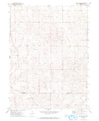
1972 Map of Gragg Ranch
USGS Topo · Published 1993About this map
The rolling Sandhills terrain of the Nebraska panhandle defines this 1970s landscape, where isolated homesteads and cattle operations mark the sparse settlement pattern. The boundary between McPherson and Lincoln Counties crosses the southern portion of the sheet, dividing a region characterized by complex dune formations and seasonal basins. This survey is particularly useful for identifying specific family holdings during the early 1970s, including Gragg Ranch, Stoddard Ranch, and Rundback Ranch. The map captures the infrastructure of these remote operations, showing the network of unimproved roads and fine red dashed lines that indicate fence and field boundaries visible from aerial photographs at the time of the field check. This level of detail provides a rare look at the spatial organization of Nebraska ranching before modern consolidation.
Find a feature on this map
4 named features on this map. Tap any name to fly to it.
Don’t see what you’re looking for? This feature index may not catch every label — zoom into the map to look around manually.
Map Details
Editions of this 1972 Gragg Ranch Map
2 editions found
Other maps of this area

1899 · North Platte
USGS Topo · 1:125,000

1902 · North Platte
USGS Topo · 1:125,000

1949 · Cody Lake
USGS Topo · 1:62,500

1951 · Tryon
USGS Topo · 1:62,500

1951 · Cody Lake
USGS Topo · 1:62,500

1954 · North Platte
USGS Topo · 1:250,000

1956 · North Platte
USGS Topo · 1:250,000

1957 · North Platte
USGS Topo · 1:250,000

1967 · North Platte
USGS Topo · 1:250,000
1972 · North Platte 2 SW
USGS Topo · 1:24,000