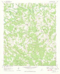
1969 Map of Graham
USGS Topo · Published 1973About this map
The Little Tallapoosa River defines the northern reaches of this borderland terrain, winding through a landscape of creek valleys and ridges where Alabama meets Georgia. In the late 1960s, the rural character of this region is evidenced by the density of community churches and named bridges, such as Muckfaw Bridge and Coles Bridge. The settlement of Graham serves as a central point, surrounded by numerous small congregational sites like Shiloh Ch, Bethena Ch, and St James Ch. To the east, the terrain rises toward Blackjack Mtn, while southern reaches near Ephesus are drained by Cutnose Creek. This survey captures the traditional agricultural and social layout of the area before modern consolidation, preserving the locations of family-associated landmarks such as the Buchanan Memorial and historic gathering places like the Bethlehem-Camp Ground Ch.
Find a feature on this map
41 named features on this map. Tap any name to fly to it.
Don’t see what you’re looking for? This feature index may not catch every label — zoom into the map to look around manually.
Map Details
Editions of this 1969 Graham Map
3 editions found
Other maps of this area

1889 · Tallapoosa
USGS Topo · 1:125,000

1892 · Tallapoosa
USGS Topo · 1:125,000

1897 · Tallapoosa
USGS Topo · 1:125,000

1899 · Wedowee
USGS Topo · 1:125,000

1902 · Wedowee
USGS Topo · 1:125,000

1953 · Atlanta
USGS Topo · 1:250,000

1957 · Atlanta
USGS Topo · 1:250,000

1958 · Atlanta
USGS Topo · 1:250,000

1958 · Carrollton
USGS Topo · 1:62,500

1964 · Roopville
USGS Topo · 1:24,000