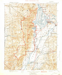
1901 Map of Grand Teton
USGS Topo · Published 1931About this map
Teton Range granite peaks and the high valley of Jackson Hole are depicted in this early survey, showing the region before major modern developments. The map provides a detailed view of the homesteading era, noting numerous family-run operations like Edwards Ranch, Sargent's Ranch, and Carmichael's Ranch that preceded the expansion of federal protections. Early tourism infrastructure is already present at the Jackson Lake Lodge and Teton Lodge, while Moran serves as a local hub near the outlet of Jackson Lake.
Find a feature on this map
97 named features on this map. Tap any name to fly to it.
Don’t see what you’re looking for? This feature index may not catch every label — zoom into the map to look around manually.
Map Details
Editions of this 1901 Grand Teton Map
4 editions found
Other maps of this area

1885 · Lake
USGS Topo · 1:125,000

1886 · Shoshone
USGS Topo · 1:125,000

1888 · Shoshone
USGS Topo · 1:125,000

1895 · Shoshone
USGS Topo · 1:125,000

1895 · Lake
USGS Topo · 1:125,000

1896 · Lake
USGS Topo · 1:125,000

1899 · Grand Teton
USGS Topo · 1:125,000

1901 · Shoshone
USGS Topo · 1:125,000

1901 · Lake
USGS Topo · 1:125,000

1901 · Grand Teton
USGS Topo · 1:125,000