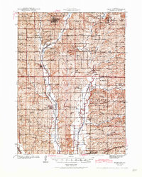
1943 Map of Grant City
USGS Topo · Published 1943About this map
The rolling agricultural landscape of Worth and Gentry counties is anchored by the county seat at Grant City and a network of small farming villages during the early 1940s. The Chicago Burlington and Quincy railroad cuts through the terrain, connecting the larger settlements of Worth and Gentry along the valley of the Middle Fork Grand River. The map reveals a dense rural infrastructure typical of the era, with dozens of family-named schools and churches serving the surrounding townships like Fletchall and Howard. Unique local landmarks such as Mt Walter and Reding Hill rise above the drainage basins of Muddy Creek and Rock Creek, while numerous country cemeteries, including Wharton Cem and Fairview Cem, offer significant detail for genealogical research into the families who settled this corner of Missouri.
Find a feature on this map
79 named features on this map. Tap any name to fly to it.
Don’t see what you’re looking for? This feature index may not catch every label — zoom into the map to look around manually.
Map Details
Editions of this 1943 Grant City Map
3 editions found

Other maps of this area

1925 · Pattonsburg
USGS Topo · 1:62,500

1925 · Stanberry
USGS Topo · 1:62,500

1925 · Darlington
USGS Topo · 1:62,500

1939 · Stanberry
USGS Topo · 1:62,500

1940 · Blockton
USGS Topo · 1:62,500

1940 · Bedford
USGS Topo · 1:62,500

1940 · Parnell
USGS Topo · 1:62,500

1942 · Grant City
USGS Topo · 1:62,500

1943 · Bedford
USGS Topo · 1:62,500

1943 · Parnell
USGS Topo · 1:62,500