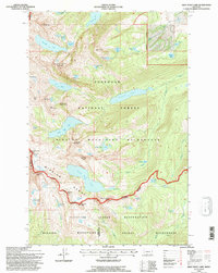
1994 Map of Gray Wolf Lake
USGS Topo · Published 1996About this map
Gray Wolf Glacier feeds a high alpine watershed at the intersection of the Mission Range and the Flathead Indian Reservation. This remote landscape, surveyed with updates from 1994, is defined by the sharp divides and permanent ice fields that separate the Swan River drainage from the tribal lands to the south. The terrain is marked by poetic and descriptive nomenclature, from the towering Daughter of the Sun Mountain to the curiously named Angels Bathing Pool and Sleeping Elk Lake.
Find a feature on this map
61 named features on this map. Tap any name to fly to it.
Don’t see what you’re looking for? This feature index may not catch every label — zoom into the map to look around manually.
Map Details
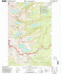
Editions of this 1994 Gray Wolf Lake Map
2 editions found
Other maps of this area

1921 · Elbow Lake
USGS Topo · 1:125,000

1955 · Choteau
USGS Topo · 1:250,000

1957 · Choteau
USGS Topo · 1:250,000

1958 · Choteau
USGS Topo · 1:250,000

1962 · Choteau
USGS Topo · 1:250,000

1965 · Upper Jocko Lake
USGS Topo · 1:24,000
1965 · Belmore Sloughs
USGS Topo · 1:24,000

1965 · Gray Wolf Lake
USGS Topo · 1:24,000

1965 · Lake Marshall
USGS Topo · 1:24,000
1965 · St Marys Lake
USGS Topo · 1:24,000