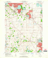
1960 Map of Grayslake
USGS Topo · Published 1962About this map
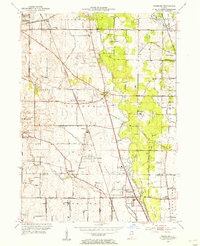
Lake County's glacial landscape is defined here by a dense cluster of water bodies and rapidly expanding mid-century residential developments. Round Lake Beach, Round Lake Park, and Grayslake show significant growth, while the northern reaches retain a network of smaller lakes like Highland Lake and Druce Lake. The southern half remains largely agricultural, punctuated by small crossroads such as Fremont Center and Ivanhoe. The sprawling grounds of St Marys of the Lake Seminary and Loch Lomond indicate the area's transition toward recreational and institutional land use. Important local landmarks for genealogical research include the Avon Centre Cem and Fort Hill Cem. This 1960 edition also traces the path of the Soo Line and the Chicago Milwaukee St Paul and Pacific railroads, which facilitated the transition of these former resort towns into year-round suburban communities.
Find a feature on this map
85 named features on this map. Tap any name to fly to it.
Don’t see what you’re looking for? This feature index may not catch every label — zoom into the map to look around manually.
Map Details
Editions of this 1960 Grayslake Map
4 editions found
Other maps of this area

1900 · Highwood
USGS Topo · 1:62,500

1906 · Waukegan
USGS Topo · 1:62,500

1908 · Waukegan
USGS Topo · 1:62,500

1920 · Grays Lake
USGS Topo · 1:62,500

1923 · Grays Lake
USGS Topo · 1:62,500

1923 · Barrington
USGS Topo · 1:62,500

1928 · Wheeling
USGS Topo · 1:24,000

1935 · Barrington
USGS Topo · 1:62,500
1953 · Wheeling
USGS Topo · 1:24,000

1954 · Rockford
USGS Topo · 1:250,000