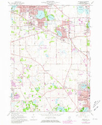
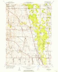
1960 Map of Grayslake
USGS Topo · Published 1981About this map
Grayslake and its surrounding glacial lake landscape are captured here during a period of significant suburban expansion in Lake County. The map documents the dense residential growth of Round Lake Beach, Round Lake Park, and Mundelein, where new subdivisions press against traditional farmland and established institutions like St Marys of the Lake Seminary. Despite the encroaching modernization, older hamlets such as Fremont Center and Ivanhoe remain distinct nodes in the township grid. The presence of the Chicago Milwaukee St Paul and Pacific and the Soo Line railroads highlights the historical transit corridors that shaped these communities. Beyond the urban clusters, specialized sites like Campbell Airport and a Drive-in Theater reflect the mid-century leisure and transportation patterns of a region transitioning from rural agricultural roots to a commuter-oriented landscape.
Find a feature on this map
74 named features on this map. Tap any name to fly to it.
Don’t see what you’re looking for? This feature index may not catch every label — zoom into the map to look around manually.
Map Details
Editions of this 1960 Grayslake Map
4 editions found
Other maps of this area

1900 · Highwood
USGS Topo · 1:62,500

1906 · Waukegan
USGS Topo · 1:62,500

1908 · Waukegan
USGS Topo · 1:62,500

1920 · Grays Lake
USGS Topo · 1:62,500

1923 · Grays Lake
USGS Topo · 1:62,500

1923 · Barrington
USGS Topo · 1:62,500

1928 · Wheeling
USGS Topo · 1:24,000

1935 · Barrington
USGS Topo · 1:62,500
1953 · Wheeling
USGS Topo · 1:24,000

1954 · Rockford
USGS Topo · 1:250,000