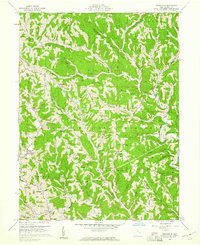
1960 Map of Graysville
USGS Topo · Published 1961About this map
Wayne National Forest dominates much of this Monroe County landscape, which is deeply carved by the Little Muskingum River and its numerous tributaries. The map documents a rural community defined by high ridges and narrow hollows, where family names are etched into the terrain at Conner Ridge Cem, Dougherty Cem, and McVay Cem. A notable archaeological site is preserved at Lamping Cem (Indian Mound) near Marr, while the local heritage of transportation is represented by a Covered Bridge in Sycamore Valley. Numerous oil and gas wells are scattered across the hillsides, illustrating the persistent extraction economy of the region. Social and spiritual life centers on small landmarks such as Pleasant Ridge Ch, Hines Chapel, and the Grange Hall near the southern boundary.
Find a feature on this map
76 named features on this map. Tap any name to fly to it.
Don’t see what you’re looking for? This feature index may not catch every label — zoom into the map to look around manually.
Map Details
Editions of this 1960 Graysville Map
4 editions found
Other maps of this area

1903 · Macksburg
USGS Topo · 1:62,500

1905 · New Matamoras
USGS Topo · 1:62,500

1905 · Woodsfield
USGS Topo · 1:62,500

1905 · Macksburg
USGS Topo · 1:62,500

1909 · Summerfield
USGS Topo · 1:62,500

1911 · Summerfield
USGS Topo · 1:62,500

1924 · New Matamoras
USGS Topo · 1:62,500

1926 · New Matamoras
USGS Topo · 1:62,500

1949 · Clarksburg
USGS Topo · 1:250,000

1956 · Clarksburg
USGS Topo · 1:250,000