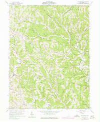
1960 Map of Graysville
USGS Topo · Published 1977About this map
Graysville and its surrounding townships in Monroe County sit within the deeply dissected landscape of the Wayne National Forest. By the mid-20th century, the region's economy was defined by a dense network of Gas Wells and timber, while the social fabric remained centered around family-named ridges and small rural institutions. The map records several notable landmarks, including the Sycamore Valley Covered Bridge spanning the Clear Fork and the Lamping Cem (Indian Mound) in the south. Genealogists will find a high density of family burial grounds such as Hartshorn Ridge Cem, Beardmore Cem, and Marr Cem located near early settlements like Sprague and Marr. The road network is largely determined by the topography, with major routes following landmarks like Barber Ridge and Moose Ridge to avoid the steep drainages of the Little Muskingum River.
Find a feature on this map
77 named features on this map. Tap any name to fly to it.
Don’t see what you’re looking for? This feature index may not catch every label — zoom into the map to look around manually.
Map Details
Editions of this 1960 Graysville Map
4 editions found
Other maps of this area

1903 · Macksburg
USGS Topo · 1:62,500

1905 · New Matamoras
USGS Topo · 1:62,500

1905 · Woodsfield
USGS Topo · 1:62,500

1905 · Macksburg
USGS Topo · 1:62,500

1909 · Summerfield
USGS Topo · 1:62,500

1911 · Summerfield
USGS Topo · 1:62,500

1924 · New Matamoras
USGS Topo · 1:62,500

1926 · New Matamoras
USGS Topo · 1:62,500

1949 · Clarksburg
USGS Topo · 1:250,000

1956 · Clarksburg
USGS Topo · 1:250,000