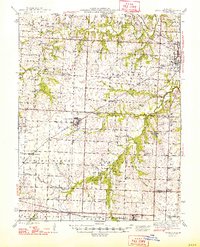
1948 Map of Green Ridge
USGS Topo · Published 1948About this map
Green Ridge and the western outskirts of Sedalia define this mid-century landscape where agricultural townships meet an established railroad infrastructure. The map traces the routes of the Missouri Pacific, Missouri Kansas and Texas, and Chicago Rock Island and Pacific railroads as they navigate the drainages of Muddy Creek and Flat Creek. This era reveals a dense network of one-room schoolhouses like Hickory Point Sch and Prairie Flower Sch, many of which served as local landmarks alongside rural churches such as Bethlehem Ch and New Bethel Ch. A distinct transition in land use is visible between the industrial presence of Old Coal Mines and the State Fair Grounds near the Pettis County seat. The survey also preserves the location of Huston Landing Field and numerous family burial grounds, including Craighead Cem and Quisenberry Cem, providing valuable spatial data for regional genealogists.
Find a feature on this map
83 named features on this map. Tap any name to fly to it.
Don’t see what you’re looking for? This feature index may not catch every label — zoom into the map to look around manually.
Map Details
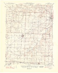
Editions of this 1948 Green Ridge Map
2 editions found
Other maps of this area

1885 · Warrensburg
USGS Topo · 1:125,000

1887 · Clinton
USGS Topo · 1:125,000

1887 · Sedalia
USGS Topo · 1:125,000

1887 · Warsaw
USGS Topo · 1:125,000

1887 · Warrensburg
USGS Topo · 1:125,000

1894 · Warsaw
USGS Topo · 1:125,000

1894 · Sedalia
USGS Topo · 1:125,000

1894 · Warrensburg
USGS Topo · 1:125,000

1894 · Clinton
USGS Topo · 1:125,000

1917 · Knobnoster
USGS Topo · 1:62,500