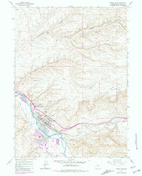
1961 Map of Green River
USGS Topo · Published 1981About this map
Green River sits at a dramatic bend in the Green River, framed by the striking geological formations of White Mountain. This 1961 topography reveals the town's identity as a critical transportation hub, where the Union Pacific railroad and the Overland Trail intersect with the rugged high-desert landscape. Local landmarks such as Tollgate Rock and The Palisades dominate the skyline above the settlement. The map highlights mid-century urban development, including Lincoln High Sch and Washington Sch, alongside historical markers and the Riverview Cem. South of the town's core, Island Park and the Waterworks occupy the riverfront, while the confluence with Bitter Creek and the presence of numerous pipelines signal the region's evolving infrastructure and resource management near the turn of the 1960s.
Find a feature on this map
34 named features on this map. Tap any name to fly to it.
Don’t see what you’re looking for? This feature index may not catch every label — zoom into the map to look around manually.
Map Details
Editions of this 1961 Green River Map
4 editions found
Other maps of this area

1954 · Rock Springs
USGS Topo · 1:250,000

1957 · Mc Kinnon Junction
USGS Topo · 1:62,500

1957 · Firehole Basin
USGS Topo · 1:62,500

1958 · Rock Springs
USGS Topo · 1:250,000

1961 · Scott Spring
USGS Topo · 1:24,000

1961 · Peru
USGS Topo · 1:24,000

1961 · Pilot Butte
USGS Topo · 1:24,000

1961 · Austin Ranch
USGS Topo · 1:24,000

1961 · Kanda
USGS Topo · 1:24,000

1961 · Green River
USGS Topo · 1:24,000