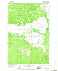
1965 Map of Greenough
USGS Topo · Published 1967About this map
The Blackfoot River and Clearwater River converge amidst a landscape defined by timber and transit in this mid-1960s survey. Much of the northern terrain is managed as the Lolo National Forest, giving way to the broad expanse of Nine Mile Prairie further south. The Chicago Milwaukee St Paul and Pacific railroad follows the winding river corridor, serving small settlements and industrial points such as Barite.
Find a feature on this map
28 named features on this map. Tap any name to fly to it.
Don’t see what you’re looking for? This feature index may not catch every label — zoom into the map to look around manually.
Map Details
Editions of this 1965 Greenough Map
3 editions found
Other maps of this area

1902 · Ovando
USGS Topo · 1:125,000

1903 · Bonner
USGS Topo · 1:125,000

1905 · Ovando
USGS Topo · 1:125,000

1919 · Drummond
USGS Topo · 1:125,000

1921 · Drummond
USGS Topo · 1:125,000

1921 · Elbow Lake
USGS Topo · 1:125,000

1947 · Butte
USGS Topo · 1:250,000

1955 · Choteau
USGS Topo · 1:250,000

1957 · Choteau
USGS Topo · 1:250,000

1958 · Butte
USGS Topo · 1:250,000