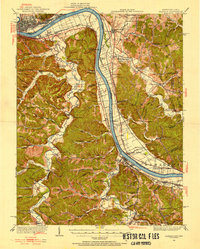
1926 Map of Greenup
USGS Topo · Published 1955About this map
The Ohio River carves a deep path through this borderland region, where the industrial hubs of Portsmouth and New Boston sit opposite the winding hollows of Greenup County. In the mid-1920s, the river valley was a primary corridor for the Chesapeake and Ohio and Norfolk and Western railroads, supporting riverfront settlements like Fullerton, Siloam, and Limeville. Away from the main river, the landscape transitions into a dense network of ridges and creeks, including Tygarts Creek and the Little Sandy River. This interior terrain is dotted with an exceptional number of neighborhood institutions, from the Forest Academy School to the Short Branch Ch, reflecting a rural population connected by unimproved roads and landmarks like Raccoon Bridge. Industrial signatures like Twin Oaks Mill and Junior Furnace indicate the historical economic reliance on local timber and minerals.
Find a feature on this map
135 named features on this map. Tap any name to fly to it.
Don’t see what you’re looking for? This feature index may not catch every label — zoom into the map to look around manually.
Map Details
Editions of this 1926 Greenup Map
3 editions found

Other maps of this area

1898 · Ironton
USGS Topo · 1:62,500

1900 · Ironton
USGS Topo · 1:62,500

1901 · Ceredo
USGS Topo · 1:62,500

1903 · Kenova
USGS Topo · 1:125,000

1904 · Kenova
USGS Topo · 1:125,000

1911 · Sciotoville
USGS Topo · 1:62,500

1912 · Oak Hill
USGS Topo · 1:62,500

1913 · Ceredo
USGS Topo · 1:62,500

1913 · Sciotoville
USGS Topo · 1:62,500

1915 · Garrison
USGS Topo · 1:62,500