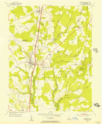
1955 Map of Greenwood
USGS Topo · Published 1957About this map
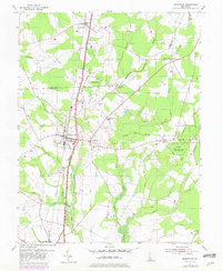
The Kent-Sussex Line divides the agricultural landscape of central Delaware in the mid-1950s, anchored by the rail and road corridor through Greenwood. The Pennsylvania railroad and the Dupont Parkway run parallel north-to-south, dictating the development of small communities like Farmington and Johnstown. Outside these hubs, the terrain is defined by a dense network of low-lying waterways, including the Nanticoke River and family-named streams like Booth Branch and Cart Branch.
Find a feature on this map
41 named features on this map. Tap any name to fly to it.
Don’t see what you’re looking for? This feature index may not catch every label — zoom into the map to look around manually.
Map Details
Editions of this 1955 Greenwood Map
2 editions found
Other maps of this area

1915 · Seaford
USGS Topo · 1:62,500

1917 · Millsboro
USGS Topo · 1:62,500

1918 · Cedar Creek
USGS Topo · 1:62,500

1918 · Harrington
USGS Topo · 1:62,500

1919 · Cedar Creek
USGS Topo · 1:62,500

1938 · Cedar Creek
USGS Topo · 1:62,500

1938 · Millsboro
USGS Topo · 1:62,500

1944 · Cedar Creek
USGS Topo · 1:62,500

1944 · Millsboro
USGS Topo · 1:62,500

1944 · Seaford
USGS Topo · 1:62,500